Uncovering Underground Infrastructure at an Operational Water Recycling Centre
Published on by Toni Abrahams
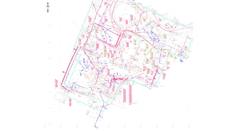
Survey Solutions was commissioned to undertake a PAS 128-compliant 3D underground utilities survey at an operational water recycling centre, supporting a wider programme of environmental compliance and infrastructure improvements.
Our specialist teams combined ground penetrating radar (GPR), CCTV drainage investigations and line and level surveys to give a clear, comprehensive picture of the site’s complex underground infrastructure. This helped the client reduce uncertainty, identify potential risks and make better-informed decisions before works began.
The Project
As part of a wider infrastructure improvement programme supporting the Environment Agency’s Monitoring Certification Scheme (MCERTS) and the Water Industry National Environment Programme (WINEP), Survey Solutions was appointed to investigate and map the underground services at an operational water recycling centre.
The project required detailed three-dimensional information on the location, alignment and depth of buried utilities, alongside a clearer understanding of the pipe networks connecting treatment infrastructure and discharge points.
With multiple generations of underground assets occupying a constrained operational site, accurate survey information was essential to support the planning and design of future improvements.
Two specialist teams were deployed over a one-week programme, combining advanced utility detection with CCTV drainage investigations and line and level surveys to develop a coordinated picture of the site’s buried infrastructure.
The Challenge
Water recycling centres are demanding sites for underground surveying. Pipelines, drainage connections, electrical services and other critical utilities often share the same confined spaces.
Years of development, maintenance and modification create complex arrangements, with services crossing at different depths and connections that existing records do not always show accurately.
The client needed reliable information on the position and connectivity of underground assets, without disrupting essential treatment operations.
The scope required the team to distinguish closely spaced services, trace pipe routes from treatment structures to discharge points, and supply accurate three-dimensional data to support the proposed improvements.
Meeting these needs demanded an integrated approach: one that could compensate for the weaknesses of any single detection method while keeping the facility running safely.
Our Approach
A coordinated investigation was conducted by the two specialist teams on complementary surveys over the course of the week.
Following PAS 128 methodology at the specified M2–M4 levels, the first team used ground penetrating radar (GPR) and complementary detection techniques to identify and map buried infrastructure. The 3D utility survey indicated the likely position, alignment and depth of underground services and showed how assets interacted in congested areas of the site.
Meanwhile, a second team conducted CCTV drainage investigations and line and level surveys, examining accessible pipes to establish connections, alignments and invert levels.
Cross-referencing the results of these methods improved the interpretation of pipe routes and increased confidence in the asset data. This was particularly valuable for pipelines between treatment tanks and discharge points, where knowing the existing connections was essential to planning future improvements.
Together, the coordinated surveys revealed far more of the underground infrastructure than any single method could have achieved alone.
The Outcome
Despite the density and complexity of underground services, Survey Solutions delivered a coordinated three-dimensional representation of the site’s subsurface infrastructure within the agreed programme.
Combining GPR utility detection, CCTV drainage investigations and line and level data gave the client a clear view of service locations, pipe alignments and connections across the operational facility. The findings highlighted potential conflicts between existing utilities and proposed works, reducing uncertainty in early design and construction planning.
The integrated data also supported better-informed decisions on pipe connections, access requirements and the positioning of new or modified infrastructure. It also supplied the underground asset data needed to plan monitoring and regulatory works within the wider environmental improvement programme.
By bringing together a combination of survey disciplines, Survey Solutions gave the client a reliable basis for later engineering assessments, helping them manage risk and plan future improvements with confidence.
The Value of Integrated Surveying
At this operational water recycling centre, Survey Solutions helped the client identify potential conflicts and reduce reliance on exploratory excavation, by using complementary non-intrusive survey techniques.
Underground utility strikes, unexpected excavations and unidentified buried assets can introduce significant safety, financial and programme risks during infrastructure improvement projects.
The integrated approach creates opportunities for measurable risk reduction, enabling the project team to assess buried service hazards earlier and make more informed decisions about proposed works.
By improving underground asset visibility, Survey Solutions helped support safer construction planning, reduce the potential for unnecessary ground disturbance and minimise disruption to essential water treatment operations.
This project highlights how early investment in specialist surveying can deliver tangible value through excavation avoidance, improved risk management and more efficient infrastructure planning, while supporting the wider environmental improvement objectives of the water sector