Land and Utility Surveyors in Leeds
Survey Solutions’ Leeds office supports projects across Leeds, West Yorkshire, North Yorkshire, South Yorkshire and the wider Yorkshire region. Our local team provides accurate land surveys, measured building surveys, underground utility surveys, drone surveys, monitoring and site engineering support for infrastructure, residential, commercial, education, healthcare and public-sector schemes. From early feasibility and planning through to construction and asset management, we help project teams understand existing site conditions before design or site work begins.
Survey services from our Leeds office
Our Leeds team provides survey services for projects at every stage of the development and construction process. Services include topographical surveys, measured building surveys, underground utility surveys, UAV/drone surveys, laser scanning, monitoring and site engineering. Each survey is planned around the project requirements, site constraints and deliverables needed by architects, engineers, contractors, planners and asset owners.
Topographical surveys for Leeds and Yorkshire projects
Topographical surveys provide accurate existing-site information, including levels, boundaries, structures, drainage, access routes, vegetation, street furniture and other physical features. Our Leeds surveyors can support urban regeneration sites, highways schemes, residential developments, commercial estates, public-sector land and infrastructure projects across Yorkshire. This information gives project teams a reliable base for feasibility, planning, design and construction decisions.
Measured building surveys for refurbishment and redevelopment
Our measured building surveys help clients understand existing buildings before refurbishment, conversion, extension, fit-out or redevelopment. Depending on the scope, the Leeds team can provide floor plans, elevations, sections, roof plans, point-cloud data and 3D outputs. These deliverables are useful for architects, designers, contractors, landlords and estates teams working across commercial, education, healthcare, residential and public-sector buildings.
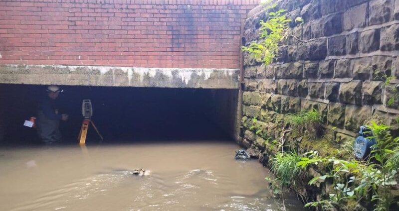
Underground utility surveys for highways, drainage and development sites
Buried utilities are a key consideration for highways, drainage, redevelopment and infrastructure projects. Our Leeds office can provide underground utility surveys to help locate and map services before excavation, design or construction work begins. Where appropriate, survey scopes can be aligned with PAS 128, giving project teams clearer information about methodology, confidence levels and output requirements.
Drone, monitoring and construction-stage survey support
For projects that require aerial information, repeat observations or construction-stage support, our Leeds team can provide UAV/drone surveys, monitoring and site engineering services. These services can help capture large or difficult-to-access sites, track movement, support setting out, verify progress and provide reliable data during construction. They are particularly useful for infrastructure, commercial and phased development projects.
Supporting projects across Leeds, West Yorkshire and the wider Yorkshire region
Leeds and Yorkshire continue to see activity across regeneration, transport, housing, education, commercial development, utilities and public infrastructure. Our Leeds office is positioned to support clients across this varied regional market, from city-centre sites and transport corridors to campuses, estates and rural locations. Local survey planning helps ensure that access, safety, programme and deliverable requirements are considered before work begins.
Survey support for highways, drainage and development projects
Highways, drainage and development projects rely on accurate existing-site information. Levels, kerbs, drainage features, utilities, boundaries and surrounding context can all influence design and construction decisions. Our Leeds team can provide the survey data needed to support engineers, designers and contractors, helping reduce assumptions and improve coordination between disciplines.
Do we provide PAS 128 utility surveys in Yorkshire?
Yes. Our Leeds office can provide underground utility surveys for projects across Yorkshire where buried service information is required before design, excavation or construction. PAS 128 can be used to define the survey quality level, methodology and deliverable requirements. This is particularly useful for highways, drainage, utilities, infrastructure, redevelopment and public-sector projects where below-ground risk needs to be understood clearly.
How our Leeds team supports early-stage design
Early-stage design relies on accurate existing information. By commissioning topographical, measured building or utility survey work before detailed design begins, project teams can reduce assumptions, identify constraints and coordinate more effectively. Our Leeds team can help define the right combination of survey services so that the information provided is suitable for planning, design development, tendering or construction.
Speak to our Leeds survey team
Contact the Leeds office if you need survey support in Leeds, West Yorkshire, North Yorkshire, South Yorkshire or the wider Yorkshire region. Share your site details, scope or tender pack and we will advise on the most suitable survey approach and deliverables.
Talk to us…
Get through to one of our specialists to help you with your project.
Leeds office
Survey Solutions
St Paul’s House, 23 Park Square S
Leeds
LS1 2ND
Directions
0113 531 6592

Click map for directions