Rail
Rail Sector Surveying
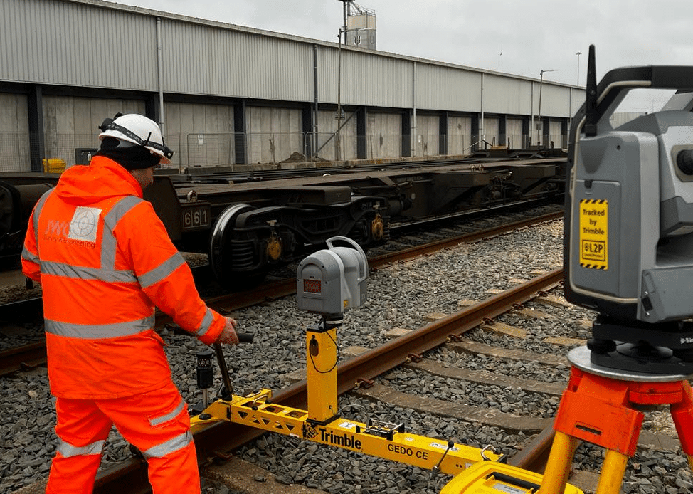
In the rail sector, managing extensive infrastructure requires precise planning, execution, and comprehensive surveying services. Whether you are a rail asset owner, an engineering consultant, or a contractor providing construction services, obtaining accurate data through various surveying and monitoring services is crucial for ensuring safety, efficiency, and regulatory compliance.
Here’s why these services are essential:
Engineering Surveys
Purpose:
- Planning and Design: Provides precise data on topography, boundaries, and existing structures, essential for planning and designing new rail projects or maintaining existing ones.
- Construction Accuracy: Ensures construction activities are carried out accurately according to design specifications, preventing costly errors and delays.
Applications:
- Infrastructure Development: Critical for constructing new rail lines, stations, and related infrastructure.
- Maintenance: Regular surveys help identify areas that need repair or reinforcement, ensuring the long-term safety and efficiency of rail networks.
Hydrographic and Land Surveys
Purpose:
- Waterway Management: Hydrographic surveys map underwater features, providing data on depth, sediment accumulation, and underwater obstructions which can affect rail bridges and tracks over water bodies.
- Topographical Insights: Land surveys provide detailed mapping of the terrain, essential for planning rail routes and infrastructure development.
Applications:
- Navigation Safety: Ensures safe passage for maintenance vessels and construction equipment.
- Environmental Protection: Assists in monitoring and managing the health of aquatic ecosystems, ensuring that construction activities do not harm the environment.
Underground Utility Surveys
Purpose:
- Utility Mapping: Identifies the location of underground utilities, preventing accidental strikes during construction.
- Structural Assessment: Helps assess the condition of subsurface structures like tunnels and culverts.
Applications:
- Safe Excavation: Ensures construction activities avoid existing utilities, preventing service disruptions and hazards.
- Infrastructure Upgrades: Regular surveys aid in maintaining and upgrading existing underground infrastructure.
Structural Monitoring
Purpose:
- Safety Assurance: Continuous monitoring of structural elements ensures they remain within safe limits during and after construction.
- Risk Mitigation: Early detection of structural issues allows for timely intervention, preventing major failures.
Applications:
- Bridge and Tunnel Safety: Essential for monitoring the integrity of bridges, tunnels, and other critical infrastructure.
- Long-term Maintenance: Provides data for the long-term maintenance of rail infrastructure, ensuring safety and operational efficiency.
Environmental Monitoring
Purpose:
- Regulatory Compliance: Ensures construction and maintenance activities comply with environmental regulations.
- Ecosystem Health: Monitors the health of surrounding ecosystems, ensuring sustainable management practices.
Applications:
- Impact Assessment: Helps assess the environmental impact of rail projects.
- Sustainable Development: Provides data for sustainable management of natural resources, minimizing environmental disruption.
Essential Certifications and Accreditations
To ensure quality and compliance, the following certifications and accreditations are crucial:
Network Rail Approval: For technologies and methodologies used in surveying and monitoring.
ISO Certifications: Such as ISO 9001 (Quality Management), ISO 14001 (Environmental Management), and ISO 45001 (Occupational Health and Safety).
RISQS Accreditation: Rail Industry Supplier Qualification Scheme accreditation is necessary for suppliers to work on rail infrastructure projects.
BIM Level 2: Compliance with Building Information Modelling (BIM) standards ensures integration with modern digital construction practices.
Make an Enquiry
"*" indicates required fields


