Survey Data Deliverables
Survey data deliverables are the backbone of intelligent planning, design, construction and asset management. At Survey Solutions, we produce high-quality digital outputs that turn real-world environments into usable, accurate and fully integrated models for your project team. From laser-precise scans to full digital twins, our deliverables ensure every decision is backed by clarity, collaboration and confidence.
What Survey Data We Deliver
We support clients across infrastructure, commercial, residential and industrial sectors with a suite of survey data deliverables, including:
3D Imagery
Using high-resolution point cloud capture, our 3D imagery provides accurate, real-world representations of structures and sites. This gives design teams, engineers and stakeholders a visual-first tool to inspect, measure and plan without multiple site visits.
- Visualise as-built conditions with millimetre precision
- Validate drawings and reduce risk in the design phase
- Export into CAD, GIS or BIM platforms
Laser Scanning
Laser scanning is the starting point for any detailed spatial understanding. We use industry-leading scanners to collect millions of data points across complex environments, fast.
- Capture internal and external geometry in full detail
- Reduce revisits with complete datasets on day one
- Output to point clouds, mesh models or Revit-ready files
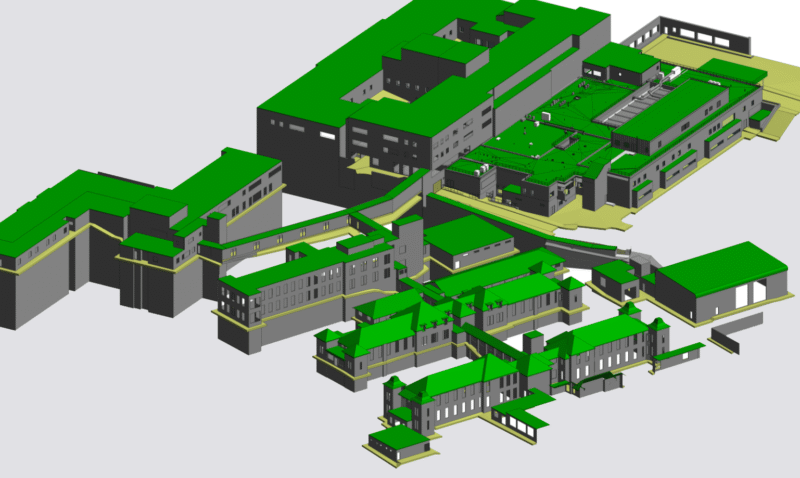
Building Information Modelling (BIM)
BIM is now a default standard for many asset owners and project teams. We deliver BIM-ready survey data compliant with ISO 19650, enabling digital twins that support design, construction and facilities management.
- Scan to BIM workflows tailored to your project needs
- Fully coordinated datasets for clash detection and planning
- Structural, architectural, MEP or civils model options
Revit Models
Our 3D Revit models turn survey data into intelligent building models. Delivered to your required Level of Detail (LOD), our models provide the digital foundation for informed project design, compliance and execution.
- Navigate, slice and interrogate the model in any direction
- Collaborate across teams with cloud-ready model files
- Generate accurate sections, elevations and schedules
Why It Matters
Our survey data deliverables unlock project value at every stage:
- Accuracy: Derived from trusted data sources, reducing rework and delays
- Efficiency: Workflows that minimise on-site disruption and maximise digital readiness
- Clarity: Models and visuals that support clear communication with stakeholders
- Compliance: Delivered to specification for planning, approvals and regulatory requirements
- Sustainability: Insights to drive more energy-efficient and resource-smart decisions
We deliver survey data deliverables for infrastructure schemes, heritage refurbishments, commercial redevelopments, housing sites and logistics facilities across the UK. Wherever you need clarity and precision, we bring certainty to your project.