Land, Utility and Building Surveys in Birmingham
Survey Solutions’ Birmingham office provides land, building and utility survey support for projects across Birmingham, Solihull, Coventry, Wolverhampton, the Black Country and the wider West Midlands. Our local team works with architects, engineers, developers, contractors, infrastructure providers and public-sector organisations that need accurate survey data before planning, design, construction or refurbishment work begins. From complex city-centre sites to commercial estates, residential developments and infrastructure schemes, we help project teams understand existing conditions and reduce risk from the outset.
Survey services from our Birmingham office
Our Birmingham office provides a full range of surveying services for projects across the West Midlands. These include topographical surveys, measured building surveys, underground utility surveys, UAV/drone surveys, monitoring, laser scanning and site engineering support. By combining experienced survey teams with modern equipment and clear deliverables, we help clients obtain the information they need for planning applications, design coordination, tender documentation, construction activity and asset management.
Land and topographical surveys for West Midlands projects
Topographical surveys are often one of the first steps in understanding a development site. Our Birmingham surveyors capture levels, boundaries, site features, access routes, hardstanding, drainage, vegetation, structures and surrounding detail so that designers and engineers can work from accurate existing-site information. This is particularly important across dense urban, commercial and infrastructure settings where early survey accuracy can help avoid design clashes and programme delays.
Measured building surveys for refurbishment and redevelopment
Our measured building surveys help project teams understand existing buildings before design, refurbishment, conversion, extension or redevelopment work begins. Depending on the brief, the Birmingham team can produce floor plans, elevations, sections, roof plans, reflected ceiling plans and 3D outputs. These deliverables give architects, designers, landlords, contractors and estates teams reliable information when existing records are incomplete, inconsistent or out of date.
Underground utility surveys and PAS 128 support
Buried services can create significant risk for design and construction teams. Our Birmingham office can provide underground utility surveys to help locate and map utilities before excavation, drainage design, new connections, highways works or site redevelopment. Where required, survey scopes can be designed around PAS 128, giving clients clearer information about service detection methodology, confidence levels and output requirements.
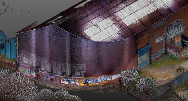
Monitoring, laser scanning and construction-stage survey support
For projects that need more than a one-off survey, our Birmingham team can support monitoring, laser scanning and construction-stage survey services. This can include movement monitoring, as-built information, site engineering, setting out support and 3D capture for complex assets. These services are particularly useful on constrained, live or phased sites where accurate, repeatable data is needed throughout the programme.
Supporting commercial, infrastructure and regeneration projects across the West Midlands
Birmingham and the wider West Midlands continue to see major investment in regeneration, transport, residential development, commercial space, education, healthcare and public infrastructure. Our regional survey team is well placed to support projects in busy urban environments, constrained sites and multi-disciplinary programmes where reliable data is essential. By working locally, we can help clients plan surveys efficiently, manage access requirements and coordinate deliverables with design and construction teams.
Survey support for live, constrained and city-centre sites
Urban projects often require careful survey planning. Access windows may be limited, pedestrian and vehicle movement may need to be managed, and neighbouring properties or live operations can affect how survey work is carried out. Our Birmingham team can help define a practical approach that captures the required information while considering safety, access, disruption and programme requirements.
What information do you need before booking a survey?
To help us scope your survey accurately, it is useful to provide the site address, boundary or red-line plan, any existing drawings, the reason for the survey, required deliverables, preferred file formats, access information and any known hazards or constraints. If you are unsure what you need, our Birmingham team can review the project requirements and advise on an appropriate survey scope before work begins.
Can our Birmingham team support live sites and constrained urban locations?
Yes. Many projects across Birmingham and the West Midlands take place in live environments, including commercial buildings, highways, public spaces, campuses, residential areas and operational estates. Our team can plan survey activity around access restrictions, working hours, site inductions, traffic management and health and safety requirements. The aim is to capture the information needed while keeping disruption to a minimum.
Speak to our Birmingham survey team
Contact the Birmingham office if you need survey support across Birmingham, Solihull, Coventry, Wolverhampton, the Black Country or the wider West Midlands. Share your site details, scope or tender pack and we will advise on the most suitable survey services, deliverables and next steps.
Talk to us…
Get through to one of our specialists to help you with your project.
Recent Projects from the Birmingham Survey Team
Birmingham office
Survey Solutions
Building 300,
Trinity Park
Solihull
B37 7ES
Directions
0121 820 8024
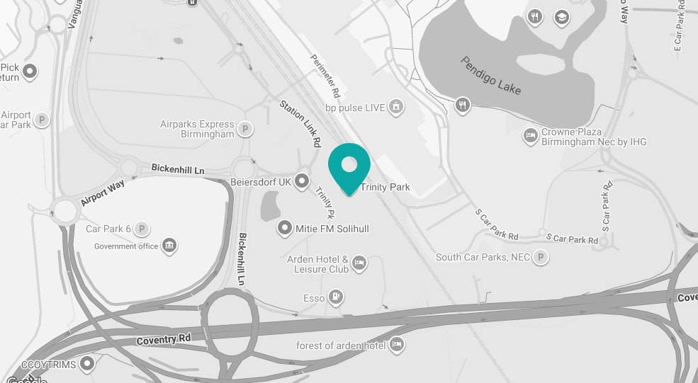
Click map to get directions


