Understanding PAS 128: The Standard for Utility Surveys
Published on by Jonathan Simpson Tarling
A utility survey involves the process of locating, positioning, and identifying buried pipes, cables, and other underground utilities/anomalies that may be present underground which is essential for construction, infrastructure, and development projects. PAS 128 is the British standard that sets out the requirements for utility detection, verification, and location.
What is PAS 128?
PAS 128 (Publicly Available Specification 128) is a specification developed by the British Standards Institution (BSI) that provides a clear and consistent framework for underground utility detection and verification. The standard outlines different survey methods, quality levels, and accuracy requirements to ensure reliable and consistent results.
First introduced to the UK in 2014 and later revised in 2022, PAS 128 establishes best practices for utility surveys. By following PAS 128, surveyors and engineers can minimise the risks associated with unknown or incorrectly mapped underground utilities.
A well-executed utility survey offers numerous advantages, such as, ensuring workforce and public safety, minimising utility damage, reducing project delays, avoiding delay and damage costs, promoting strong relationships between clients and surveyors, etc.
The processes for conducting an Underground Utility Survey in alignment with PAS128 standards
As pressure on the UK’s infrastructure continues to increase, PAS128 offers a structured approach to:
- Clarify the services and methods used
- Ensure consistency in data capture
- Classify results and their associated confidence levels
- Standardise deliverables
- Establish accountability for the work undertaken
The successful detection and mapping of underground utilities involve combining various techniques into a single, interpreted plot. The techniques and methodologies used will primarily depend upon the required outcome for the survey, the site conditions and the type of pipes or cables being targeted.
What are the 4 levels of a PAS 128 survey?
Listed below are the four levels of PAS 128 survey accuracy, each with its own methodology. These are listed in order from the least detailed type of utility survey to the most detailed utility survey. In order to progress onto the next level, you must complete the previous level survey first. This is to ensure safety and robust data whilst conducting these types of survey.
TYPE D: Desktop Utility Record Search
The lowest quality survey, that draws data from a database of known utilities in an area.
Using utility record data (data that has not detected by geophysical methods) can cause limitations as the drawings are often dated and sometimes comprise of sketches. The data is valuable to gain a rough insight into the type of services and where they might be located within an area, desktop information should be treated as historical as the buried assets present might have changed since the drawing was last updated.
TYPE C: Site Reconnaissance
A survey that combines documented utility records with on-site data.
Site reconnaissance comprises of validating utility records with an on-site visual inspection to assess if any conflicts need to be resolved.
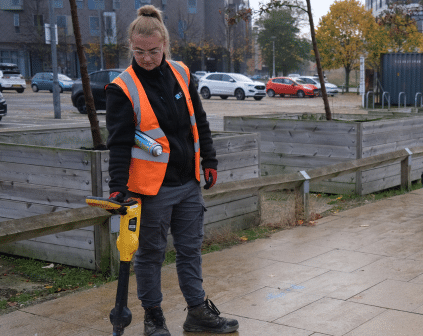
TYPE B: Detection
A utility survey that uses geophysical methods to locate utilities.
Detecting utilities using geophysical methods involves the use of electromagnetic locators (EML), sondes, magnetometry and ground-penetrating radar (GPR) to determine their horizontal and/or vertical positions. Although a utility survey is sometimes referred to as a “GPR survey,” this is technically incorrect, as GPR is only one component of the overall methodology.
TYPE A: Verification
The highest quality survey that uses physical examination to identify and locate utilities.
Verification is the process of manually exposing a utility and measuring and recording its accurate location in addition to other relevant attributes. These surveys are often carried out by strategically positioned vacuum excavation, hand-dug trail pitting or visual inspection within a utility chamber.
What Utility surveys can Survey Solutions provide?
Our Senior Utility Surveyors work towards achieving a Level 5 QCF Diploma in Senior Utilities Mapping Surveying in accordance with PAS 128 specifications to ensure the output of their surveys are to the highest possible industry standards. In addition to this, they can explain and advise on the scope of work and offer project specific advice, providing a trustworthy service.
Are you working on any projects that requires an underground utility survey? Email contactusweb@survey-solutions.co.uk and you will be directed to your area representative that can support you with any project related questions.