How to Interpret Topographic Survey Maps
Published on by Toni Abrahams
A topographic survey map is the foundation for design and planning, as they accurately record existing features and ground levels, enabling constraints and opportunities to be assessed from the outset. Architects, Engineers, and Consultants rely on topographic survey data to develop proposals that respond accurately to existing site conditions.
A Client Guide on Reading a Topographic Survey Map
At first glance, a topographic survey Topographic Survey may appear highly technical, as it typically includes contour lines, level data, and a range of symbols that are familiar to Surveyors and Engineers but less so to clients. However, with a clear understanding of the key elements, it becomes a practical and informative document that supports better decision-making.
This guide explains how to interpret a topographic survey map, what to focus on, and how it informs the design and delivery of a project.
What Is a Topographic Survey Map?
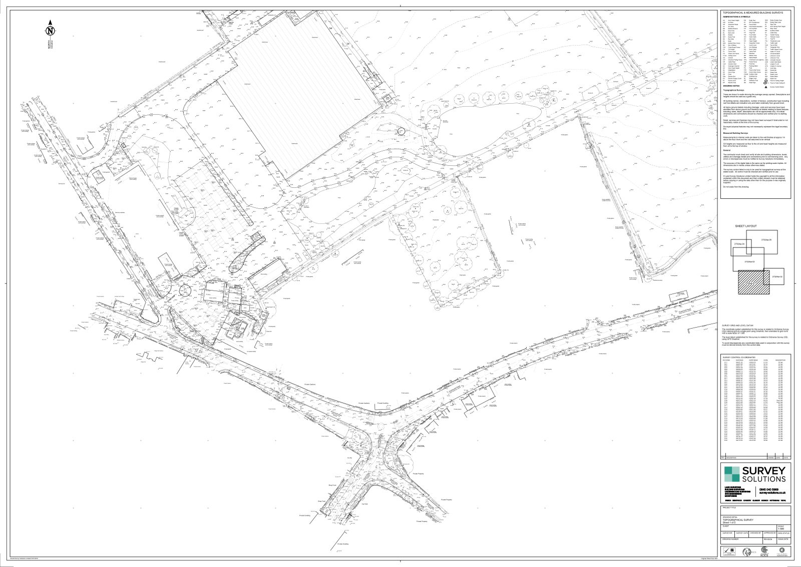
A topographic survey map is a detailed, measured representation of a site. It captures the position of physical features and illustrates changes in ground level using elevation data.
The survey will typically include but is not limited to, buildings, walls, fences, roads, paths, vegetation, drainage features, and utility covers. It also shows contours and spot levels, which define the shape and gradient of the land, alongside the surface type.
Why is a Topographic Survey Important?
A topographic survey removes uncertainty during the early stages of a project, as it provides a clear understanding of how the land slopes, how water is likely to behave, and what physical constraints may influence the design.
A reliable survey uncovers any potential issues at the beginning of a project, enabling efficient planning, while reducing overall project risk, timescales and build costs. Without accurate survey data, project teams are required to make assumptions. This can result in design revisions, delays, and additional costs during construction.
How Topographic Data Contributes to Project Success
Topographic data enables design teams to work with accurate data, reducing the likelihood of errors and improving coordination between disciplines.
Accurate data contributes to an efficient design process, improved cost certainty, and fewer unforeseen issues during construction. Early clarity around site conditions allows risks to be identified and addressed before they become problematic.
How to Read a Topographic Survey Map
A topographic survey documents both position and elevation of site features that are visible on the ground or above. Interpreting both aspects is key to understanding the site.
Each contour line represents a consistent elevation, allowing you to see how the ground rises and falls. Where contour lines are closely spaced, the gradient is steep. Where they are more widely spaced, the terrain is relatively flat. Closed contours may indicate either a raised feature or a depression, depending on the associated levels.
Spot levels provide additional precision. These are individual height measurements taken at specific points across the site. They support detailed analysis of ground conditions and are particularly important for drainage design, foundation planning, and setting finished floor levels.
Scale and orientation should always be considered. The scale defines how distances on the drawing relate to actual measurements, while the north arrow establishes direction. Both are essential when assessing layout, access, and environmental factors such as sunlight.
Physical features such as buildings, boundary features, hard surfaces, vegetation, and drainage elements often influence design decisions and may introduce constraints that need to be addressed during the planning and construction process.
Forms of boundaries will also be shown, such as fences, walls, and hedges. It is important to note that while these indicate what is present on site, they do not necessarily confirm legal boundaries. Legal boundary positions should be verified separately through title documentation.
Understanding Levels, Slopes, and Drainage
A key benefit of a topographic survey is the ability to understand how water will move across the site. As water flows downhill, the elevation data highlights potential drainage paths, high points, and low-lying areas.
Low points may be more susceptible to water accumulation, particularly if drainage infrastructure is limited. Steeper gradients may require additional design consideration, including retaining structures or ground level adjustments.
These factors can influence both the feasibility and cost of a project. While technical analysis is typically undertaken by engineers, a general understanding of levels allows clients to better interpret design recommendations.
What to focus on
Instead of interpreting every detail, focus on the site’s overall characteristics. Assess whether the land is flat or sloping, identify significant changes in level and note key features such as trees, drainage points, and access routes.
This approach supports informed discussions with your project team. It helps you understand how site conditions affect design proposals and identify potential constraints early.
Common Questions
Clients often ask about the detail level in a survey. Including contour lines, spot levels, and feature data ensures accuracy for design and construction. While not all technical elements require interpretation, understanding basics offers valuable context when reviewing drawings and proposals.
Another common question concerns planning requirements. Often, a topographic survey is required or strongly recommended to support planning applications and detailed design.
Need support with your topographic survey?
At Survey Solutions, we provide more than just accurate, high-quality topographic survey data. We are Survey Consultants, that collaborate with you throughout each stage of a project.
Whether undertaking a residential project or a larger development, we provide the information you need to proceed with confidence. To discuss your project or request a quotation, please complete the form below.